
Thank you for reading our post, please rate this article at the end.
Reading Time: 7 minutesLast Updated on May 30, 2026 by Paul Clayton
Table of Contents
Chartplotter vs GPS Explained
Key Takeaways
-
- Chartplotter vs. GPS Relationship: A Chartplotter is essentially a display system that uses GPS data to function. GPS provides the raw location coordinates, and the Chartplotter visually plots this data onto nautical charts (like a nautical Google Maps).
- GPS Function: The Global Positioning System determines a vessel’s exact location, speed, and direction using signals from orbiting satellites (trilateration). GPS data is crucial for navigation, fishing, and search and rescue operations.
- Chartplotter Function: The primary role of a chartplotter is to provide a visual representation of navigation. It displays the vessel’s path on raster (electronic paper charts) or vector (layered, mathematical) maps, helping users easily plan routes, follow tracks, and, most importantly, identify and avoid underwater hazards like reefs and shallow areas.
- Ease of Use: GPS-only devices are typically used by expert navigators comfortable with raw coordinates. Chartplotters are far easier for most boaters to use because they present the positional data in a simple, intuitive map format.
- Necessity on the Water: Having a GPS/Chartplotter system is a necessity, not just a convenience. It is an indispensable safety tool for navigating safely back to shore, especially during unexpected events like fog or mechanical failure.
Regarding navigation systems, two terms often come up: Chartplotter and GPS. Although they are sometimes used interchangeably, they have distinct features and functions.
Marine navigation is a challenging task for commercial vessels and fishing boats. One must have the expertise and knowledge of navigation in all water bodies. One can find several navigation tools and equipment to assist fishermen, ship captains, and their crews.
These tools are often digital and primarily infallible. Today’s crews rely on these tools to determine the vessel’s position, speed, and direction, as well as to identify underwater hazards and obstructions that can be hazardous to ships and boats.
Two of the most essential types of equipment that are usually used interchangeably are GPS and a Chartplotter. Both devices have pros and cons, so let’s examine GPS vs. Chartplotter in more detail.
Chartplotter vs. GPS: Chartplotters work in conjunction with GPS.
Think of Chartplotter as a visual representation of your surroundings that uses GPS coordinates to pinpoint your location. It’s like Google Maps but for nautical navigation.
A chartplotter is easier to use than GPS coordinates; however, I wouldn’t recommend relying solely on it.
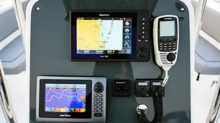
Chartplotters

Chartplotters are electronic navigation tools that show a craft’s exact position through charts and maps. They are really helpful in knowing what is below the water level and the exact location of the craft. A chartplotter uses GPS to display the ship’s location; without GPS, a chartplotter will not function independently.
It will show the vessel’s speed, the time it will take to reach the destination, and the distance between the destination and the vessel. All these data points are provided in real-time to keep the data relevant to the changing surroundings.
Chartplotters help one avoid hazards like reefs and shallow rocks.
All this data can be stored, and preloaded routes can be created before starting any voyage. The routes can be edited at any time and are represented on the screen through a visual representation.
Chartplotters also show the waypoints in numbered form, and the boat’s position is shown relative to those numbered points.
Functions of Chartplotters
- Navigation: This is the primary function of this navigation equipment, as it allows users to enter their destination in the form of coordinates. Chartplotters using these coordinates can give the boat’s speed, bearing, and heading details. The speed provides the estimated time it would take to reach the destination; the heading tells the current direction of the vessel, and the bearing tells which direction one needs to follow to reach the destination.
- Routes: A Chartplotter can also provide the exact route details one needs to follow to reach the destination in time. The route is given as waypoint-to-waypoint directions.
- Tracks: This equipment collects information along the entire route and stores it, allowing one to follow the same route and track the return journey. The recording function is particularly helpful in tumultuous waters with many obstructions, as it allows one to follow the same track to avoid those obstructions.
Charts Used in Chartplotter
Without a chart, there is no meaning to a Chartplotter. The charts represented are analogous to the paper maps. There are two types of charts involved:
- Raster charts are electronic versions of paper charts. They contain detailed information and require a significant amount of memory.
- Vector charts: These charts mathematically represent all the elements and give a layered view of the objects.
Benefits of Using a Chartplotter
- Chartplotters are great for recording one’s route for future reference. Therefore, the chances of getting lost are minimized.
- Chartplotters are also great for identifying obstructions and anything else that may be difficult for the vessel to see without this device.
GPS

A global positioning system (GPS) is a tool that is used extensively for navigation and routing.
GPS is used in marine navigation today to find the best routes and measure the vessel’s speed. GPS is also used for marine operations, including search and rescue, fishing, and navigation.
Geopositioning using GPS is accomplished through the collaboration of satellites and receivers. GPS receivers calculate the distance from at least three satellites orbiting the Earth, and the exact location is shown by trilateration. This is how ships and fishing boats determine their exact location.
Functions of GPS
- Location: GPS helps officers and fishermen find the exact location of vessels and boats in open waters, ports, and harbors. The ship’s exact location helps determine the speed with which the vessel is moving and how long it will take to reach the destination. The exact location of ships helps maneuver through crowded ports, which can lead to accidents.
- Underwater survey: Oceanographers utilize this GPS application to conduct underwater surveys. The GPS data helps place buoys and map their waypoints. It also helps locate underwater hazards that can pose a danger to ships and boats.
- Fishing: GPS technology has a significant impact on fishing, making it easier to locate fish. Almost every commercial fishing fleet utilizes GPS to locate the densely populated areas of fish and track their movements and migrations throughout different seasons.
- Maritime management: Chartplotters play a crucial role in managing the world’s largest ports, where GPS technology enables the efficient operation of container logistics. They help transfer and place the containers while keeping track of the entry and exit from the port. This has substantially reduced the number of misplaced, lost, and misdirected containers, thereby significantly lowering operating costs.
Types of GPS Devices
There are two types of devices that are used for positioning:
Handheld devices
Two things make them highly effective: firstly, they are accurate, and secondly, they are cheap. Being handheld, it is easy to carry around and take with you wherever you go.
When used on a ship or a boat, they come with a mounting bracket that makes it easier to use when the vessel hits rough water.
One of the drawbacks of handheld devices is that they are small. Due to this, the controls are minimal and can sometimes be challenging to use.
Computer Connected GPS
When connected to a computer, the GPS navigation system becomes highly useful as computers are faster and more efficient than other devices. Computers can be connected to various devices, such as sensors, chart plotters, and GPS marine navigation systems, making them cost- and time-efficient.
The most significant advantage of using the computer for GPS navigation is that one can plan and navigate simultaneously using several software and programs. The computer-connected GPS can also create a 3D display, making navigation easy and safe.
The computers are always kept below deck because they are not easily visible in bright light. Other than just computers, today, laptops are also used for connecting to GPS.
Benefits of GPS
- GPS systems are precise regarding their positioning capabilities, which helps boaters and anglers navigate through confusing routes without difficulty.
- GPS systems are fast and accurate when providing the vessel’s position, speed, and bearing. This makes navigation time cost-efficient, as one can choose the correct route to reach the destination.
- Helps in buoy positioning, sweeping, and dredging operations.
- GPS is highly effective in port management and maintaining the logistics of the containers.
- It helps ensure the overall safety of the vessels.
Comparing GPS vs Chartplotter
We should tell you straight off the bat that Chartplotters contain GPS units. The main difference is that Chartplotters present GPS data in an easy-to-understand visual manner (think Google Maps), whereas GPS data consists only of latitude and longitude.
A GPS is a big system composed of satellites that transmit positional information to the receiver, which helps calculate the exact location using the satellite positions. Chartplotters are just a simple system that shows maps and plots objects on those maps.
A GPS is all about the exact location, using latitudes and longitudes as its parameters. It cannot plot the object’s location on a map; this task is performed by the chart plotter, which plots the location on the map and stores it in memory.
Chartplotters are now advanced enough to display the location and distance between two places, as well as the easiest route between them.
GPS-only devices are used only by expert navigators with expertise and knowledge about reading longitudes and latitudes, and can, using them, know their exact location.
However, Chartplotters can be used by even those with little or no navigation knowledge. The chartplotter is embedded with GPS systems, and the location is then plotted on a regular map, which anyone can easily read.
Large vessels and ships utilize GPS-embedded chartplotters to provide an eagle’s-eye view of their surroundings and to indicate their position in the future.
In short, GPS is used to determine the exact location of a ship or vessel, whereas Chartplotters are necessary to determine the location on a map, making navigation easier.

Do I Need GPS on my Boat?
Even those who tread familiar waters or never venture far from the shore should seriously consider having a GPS/Chartplotter on their boat.
Unexpected circumstances such as sudden fog, mechanical problems, or late-night navigation are common. In such situations, having GPS on your boat is not just a convenience but a potential lifesaver.
It provides the necessary guidance to navigate safely back to shore, making it an indispensable tool for any boater. So, the answer to “Do I need GPS on my boat?” is a resounding yes.
Final Thoughts
When comparing Chartplotter vs. GPS, each device offers its own strengths in navigation technology. Chartplotters, which integrate GPS technology with electronic navigational charts (ENCs), provide comprehensive marine data, including speed, direction, and even tide monitoring.
This information is crucial for planning routes and marking waypoints, particularly in complex marine environments. GPS devices, however, primarily offer location information and simple directional guidance.
While they lack Chartplotters’ marine-specific features, their simplicity can benefit users who need straightforward location details.
However, the ability of chartplotters to connect with other marine systems significantly enhances their navigation capabilities, making them a more comprehensive solution for maritime navigation.
Ultimately, the choice between a chartplotter and a GPS will depend on the user’s specific requirements and preferences.
Home page
Back to the top of the page